Country clubs, championship golf courses, lovely lakeside cottages, marinas, what do all these things have in common? They are all characteristic of the Ontario municipality of Muskoka!
Muskoka is Ontario’s hidden vacationing gem, a tranquil municipality that offers almost unlimited potential for exploration. So sheltered and quiet that internationally recognized figures like Mark Wahlberg and David Beckham have chosen this spot for their summer getaways to escape their hectic celebrity lifestyle briefly. It didn’t take long to realize their reputation will always precede them.
Muskoka is not a luxury vacation destination. Yet it offers untapped natural splendor and opportunity for varied outdoor activities like jet skiing, snowboarding, snowshoeing, golfing, cycling, hiking, swimming, and kayaking.
Suppose you’re up for a memorable outdoor adventure, and you’re undaunted by the region’s rugged terrain. In that case, several local waterfalls and national parks deserve a spot on your itinerary.
We’ve selected five of Muskoka’s most beautiful waterfalls in the Huntsville area. So keep reading and pick your next destination!
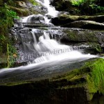
Oxtongue River-Ragged Falls Provincial Park

Oxtongue River-Ragged Falls Provincial Park is close to the more popular Algonquin Provincial Park, located northeast of Huntsville.
Visitors often overlook Oxtongue River-Ragged Falls in favor of Algonquin Provincial Park, yet its appeal and attractions are certainly on par with the considerably larger Algonquin Park.
Ragged falls are one of the park’s main attraction points. The resounding falls are both beautiful and awe-inspiring, showcasing the raw power of glacial melt water. The park is about 34 km (21mi) from Huntsville or around a 30-minute drive.
Once there, you can leave your car at the designated parking lot and commence on the less than a mile-long trail along jagged terrain that leads to remarkable views of the falls.
Named one of Ontario’s top 10 waterfalls, Ragged Falls is not a destination you want to miss if you’re up for a challenging (but not too challenging) adventure near Huntsville.
Stubb’s Falls
Stubb’s Falls is part of Arrowhead Provincial Park and is one of the best areas for outdoor recreation near Huntsville. The park provides fantastic opportunities for hiking and mountain biking. The nearby Mayflower Lake, Arrowhead Lake, and two local rivers (Big and Little East Rivers) are also ideal locations for fishing, boating, and paddling.
Arrowhead Lake has several sand beaches great for swimming, accompanied by quiet camping sites. In addition, it includes about 15 kilometers of hiking trails, including one that will take you to Stubb’s Falls.
The trail leading to the falls is less than 3km (1.5mi) long and can take up to 40 minutes to complete by foot. It is properly maintained and visibly marked, and while wide at the start, it gets narrower and steeper as you climb, so make sure you wear appropriate shoes.
The park is just over 6 miles north of Huntsville. You can stop by the Arrowhead Inn on your way to Stubb’s Falls trail or back. The inn is about half a mile (1km) before the trail.
Skeleton Falls
Skeleton Falls, also known as Minnehaha Falls on Skeleton, is in the Parry Sound District, just west of Huntsville.
It is a 30-minute drive along a 20-mile road to the falls from Huntsville. But, despite an ominous-sounding name, Skeleton Falls is nowhere near as dangerous or life-threatening. If anything, the cool air, crystal-clear waters, and ponds on Skeleton River will reinvigorate you.
There is a parking lot, and the trail to the falls is close by, though you may have to make some effort to find it.
It is advisable to travel in a group with someone who knows the trail and the path to the falls, as the trail is not always clearly marked. It is a steep, sloping walk to the falls, so be sure to dress appropriately and avoid carrying heavy luggage.
The best time to visit the falls is between May and September.
High Falls
A 20-minute drive south of Huntsville (about 18 miles) will take you to Muskoka High Falls. The falls are less than 4 miles north of the city of Bracebridge.
Muskoka High Falls are wide and steep but not less attractive, despite a local dam and power station that diverts water from the Muskoka River.
Here it is also advisable to travel with someone familiar with the falls’ location as it can be easy to miss. Once you find the trail, it is an easy walk to the falls, making it convenient for a family trip.
Locally called the “Niagara of the North,’’ the Muskoka High Falls are among the largest and steepest in Ontario.
There are also three smaller falls near the adjacent Small High Falls, alongside convenient camping grounds, cottages, and a beachfront waterpark, among other attractions.
Rosseau Falls
About 27 miles (44km) west of Huntsville is the cascading Rosseau River, home to Rosseau Falls.
If you’re planning on visiting Skeleton Falls, which is about 5 miles east of Highway 141, you should also try to spare time for Rosseau Falls. You can easily get to the falls via Rosseau Lake Road 3, which is about half a mile west of the Upper Falls.
There is also the Lower Rosseau Falls as an extension to the upper falls. The lower falls are about half a mile downstream from the upper falls and rapid whitewater streams from the river.
Beautiful vistas of Lake Rosseau and the upper and lower falls, accompanied by many picnic areas off highway 141, make the Upper and Lower Rosseau Falls a must-visit spot in Muskoka.
Where to Stay When Visiting the Falls
Muskoka Cottage is one of the quietest and most accommodating rental cottages in and around Huntsville.
The property is almost perfectly positioned to commence on any local adventure and is less than an hour’s drive even to the farthest waterfall on this list.
The cottage is about a 10-minute drive from Huntsville and can also be reached by boat. It is perfect for a relaxing stay with family or friends, equipped with a hot tub overlooking Vernon Lake, a games lounge, and several canoes and kayaks. The property is also close to the Arrowhead and Algonquin provincial parks and a local ski resort, making it a suitable destination for a winter vacation as well.
If you’re using a jet boat, the possibilities for adventure are limitless as Lake Vernon connects with three large lakes: Fairy Lake, Peninsula Lake, and Mary Lake. This network of lakes provides tens of miles of water to explore the local lakefront.